The Monashee Almanac is an online journal that shares history, mysteries and stories about early British Columbia and in particular the Monashee, Okanagan and Shuswap.
Celebrating History, Mysteries & Stories
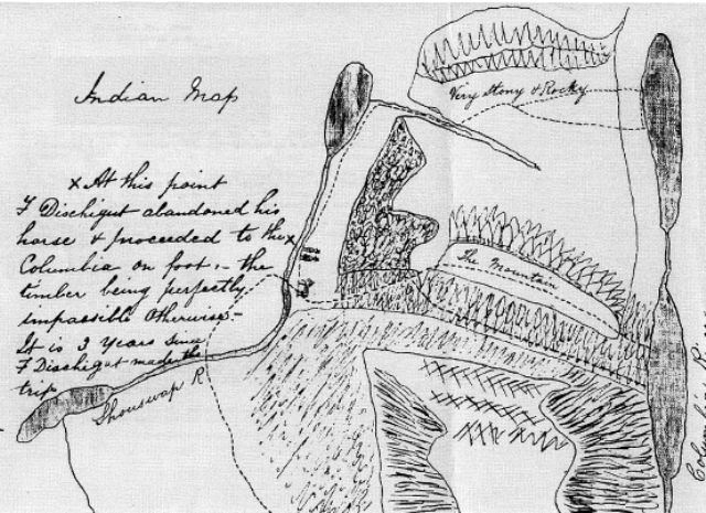
The Indian Map
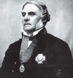
In the summer of 1862 Governor James Douglas sent W.G. Cox (William George Cox), Magistrate and Gold Commissioner at Rock Creek, to explore the territory between the head of Okanagan Lake and the Columbia River with a view to establishing a "horse road" (a pack-horse trail). Cox and his two Native guides (who, he said, were the "only Indians acquainted with that portion of the road") did not complete this exploration.
Starting from Tal d'Epinette at the head of Okanagan Lake, and passing the site of Vernon, they travelled as far east as the future Cherryville where, owing to a shortage of food and dense, fallen timber, they turned back. However, his guides had reached the Columbia River three years before with "F. Dischigut," probably François Duchoquette, a Hudson's Bay Company trader, who, in 1859, was in charge of the almost abandoned Fort Okanagan. Cox undoubtedly questioned his guides about their knowledge of the territory he had not seen, and the three of them created the map that is reproduced on the opposite page (above). It appears with the title "Indian Map" on a fair copy of Cox's map made by Cpl. J. Conroy. Survey Branch, Lands and Works Department, Royal Engineers.
Cox probably drew the map, but the information on it came from his Native guides. The two lakes shown on "Shouswap River" are now Mabel and Sugar Lakes. The horse was abandoned near the site of Cherryville, at or near where Cox gave up. Probably one of the two men in top hats is Duchoquette. More important, the map shows several Native routes between the Shuswap and Columbia Rivers. From the vicinity of Cherryville, two routes ran east, either over "the mountain" (Cherry Ridge) or by a lower and more southerly route up Cherry Creek and down Plant Creek. In 1859, however, Duchoquette and his Native guides had apparently continued north to Sugar Lake. There they turned east and probably hiked to Sitkum Creek and along the north side of South Fosthall Creek to the Columbia River, along which they travelled south a short distance before returning.
R.C. (Bob) Harris.
William George Cox's report of the journey that included the "Map of the proposed road," was entered into the governments official Colonial Correspondence on August 8th 1862 which represented the first time that the travel route to the area we now know as Cherryville or the Monashee is indicated as a “place”.
Though still nameless and known only by its geographic features and the place where François Duchoquette and his guides left their horses so that they could continue on foot, Conroy's tracing of Cox's map became part of the Surveyor General Plan 26 T3, Roads and Trails [MSEC 1862-82B, sh 1/2 and 2/2] on September 3, 1862.
In 1862, the “x” on the old Indian Map was the end of the road, 150 years later we know the road as Highway 6, and the place as Cherryville.
The Indian Map:
X Marks the Spot
Cherry Creek
August, 8th 1862
Sidebar:
R.C. (Bob) Harris
Bob Harris was born in England in 1922. After he served with the Royal Engineers during World War II, he graduated with a degree in Civil Engineering from the University of London in 1948. In 1950, Harris and his wife moved to Vancouver where he worked for 25 years for the Dominion Bridge Company. Then, in 1975 he moved to the Structural Engineering Company of Buckland & Taylor where he remained until his death in 1998. He was responsible for the design and/or construction of several bridges in the Vancouver area, namely Granville, Second Narrows, Oak Street and Port Mann Bridges.
He was a member of the B.C. Mountaineering Club, North Shore Hikers, the Vancouver Naturalist Historical Society, and a volunteer Warden for Ecological Reserve Number 48. He was also commissioned to provide hiking trails (a total of 75) for B.C. Outdoors Magazine. R.C. (Bob) Harris was an engineer by profession but an historian at heart, who enjoyed the challenge of finding all the old trails in the field. He spent over 20 years visiting the Provincial Archives and the Department of Lands in Victoria, accumulating a large mass of maps, diaries and fieldbooks of the early explorers, surveyors and road builders, geologists and miners. His massive collection can now be found in the UBC Library and Archives.
Commissioned by Gov. James Douglas (Above) the report included the "Map of the proposed road," On August 8th 1862 the travel route to the area we now know as Cherryville or the Monashee is indicated as a “place”.
R.C. (Bob) Harris a well known BC historian, spent time researching and following the early footsteps of British Columbia’s first road builders in the southern interior. This is the story that he wrote regarding the creation of a road to what is now Cherryville. He titled it “The Indian Map”.